IMAGE AND SOCIETY - INTERACTIVITY: OVERVIEW
We have studied several topics concerning Georgian cities: the urban environment, society and culture, science and industry; we have used several approaches and tools, ranging from maps to databases. We can now look at several issues related to the representation of the past and its complexity - the possible ways of associating the different types of images we have of such varied fields: maps, photos, interactive images, to give a complex view of the society of the times, using composite images evoking the contrasts of the past. We shall also look at the representation of cities in literature.
- Geography and photography: Images of places and maps, how far do they correspond? can you plot photos on maps, how can photographic and topographic conventions be coordinated?
RollOver the image to see alternative screens of the app

- Geography/images for Georgian cities: we have now seen numerous ways of coordinating maps and images of places, or or combining past and present views. On the Georgian Cities website, you may find a summary:
* image maps help you visualise buildings on a map, by opening on views when clicking on their icons on a map. See the page of examples in Georgian Cities
* double images:
- rollover images can alternate between past and present views of the same site, as in Turner's engravings of a mediaeval abbey and a recent bridge in the same area (1820s).
- you also have the option of 'compositing' two images by using an image editing program which will make two photos gradually fuse into one another, as here a 'collage' effect can be used to suggest the historical sequence of successive technological eras in Manchester - the canal age (18th century) followed by the railway age (19th century) - you may learn to practise such image programs yourselves.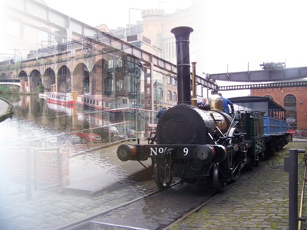
- In literature, the hypertext presentation now allows us to have new approaches to literary text and to the representation of place and space in novels.
Cities in literature play a variety of roles; they appear in the diaries of travellers as well as in novels as a setting for the adventures of characters, who describe them.
In recent years, the question of the representation of urban spaces in literature has been investigated, as part of the 'spatial turn' - the exploration of the role of the spatial dimension in the social sciences. Online tools have added extra dimensions to such problematics: 'spatial humanities' linking cartography and literature such as the study of the Lake Country as an inspiration (University of Lancaster), and hypertext search. See Georgian Cities/ Topics/Culture and the Arts/Literature, which contains both extracts from Georgian texts and present-day criticism dealing with the literary use of online search tools.- In the exercises of the present chapter we shall see how we can ourselves practise relating cartography and photos, and how to study the spatial dimension in literature with hypermedia tools.
In the forum we shall discuss image interpretation.
.
Modifié le: mercredi 19 juin 2019, 20:42